Namayingo District is our Fortress
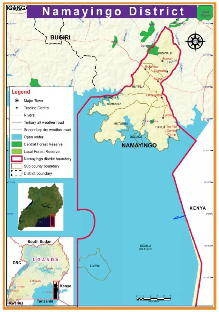
The Namayingo has a total area of 532.9 km2 of which ¼ is dry land and the rest is covered by the water bodies
75% of the district is in Lake Victoria, with 16 Islands & out of which 9 islands are currently habitable.
About Namayingo District
Namayingo District is located in the eastern part of Uganda, bordered by Lake Victoria to the south, which provides the district with significant aquatic resources. It is part of the larger Busoga sub-region and is situated within the Eastern Region of Uganda. Namayingo is one of Uganda’s newer districts, having been carved out of the larger Bugiri District in July 2010.
Predominantly a rural area, with its geography characterized by a combination of hills, valleys, and water bodies. The district has a coastline along Lake Victoria, which influences the local economy, culture, and lifestyle. The terrain is generally hilly, with fertile soils in some areas, suitable for agriculture.
Namayingo District is divided into several sub-counties, each comprising several villages. The district has its headquarters in the town of Namayingo, which is also a key administrative and commercial hub. Some of the major sub-counties include Namayingo town council, Buyinja, Buswale, Banda, Banda town council, Mutumba town council, Mutumba rural, Sigulu island, etc.
The population of Namayingo is primarily composed of various ethnic groups, with the Basoga being the dominant ethnic group in the region. The population is largely rural, with agriculture being the mainstay of the economy. There are also small urban centers within the district, but the majority of people live in villages.
Economy
Agriculture forms the backbone of Namayingo’s economy. The fertile soil and favorable climate conditions support the cultivation of various crops, including:
- Bananas (matoke)
- Cassava
- Maize
- Sweet potatoes
- Beans
- Groundnuts and sunflower
Fishing is also a significant activity for the residents, with many people relying on Lake Victoria for their livelihoods. The lake is rich in fish species such as tilapia, Nile perch, and various types of small fish, which are caught for local consumption and sale.
Gold Mining
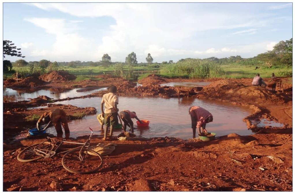
The discovery of gold in Namayingo is relatively recent, but it has quickly gained prominence. The district, especially in areas like Bumangi and Bukatube, has seen a rise in artisanal and small-scale mining activities. The existence of gold deposits in the region was first recognized through geological surveys and later confirmed by both local miners and commercial prospectors.
Gold mining also brings a complex set of environmental, health, and social challenges. Addressing these concerns through better regulation, sustainable practices, and community engagement will be crucial to ensuring the long-term benefits of gold mining in the district.
Infrastructure & Challenges
Namayingo has been making strides in improving its infrastructure, though challenges remain. Roads, especially in the more remote areas, are often in poor condition, making transportation difficult. The district is also working on improving access to clean water, healthcare, and education. The government, along with various non-governmental organizations (NGOs), has been involved in various development projects aimed at improving the living standards of the people.
The district has several primary and secondary schools, but there is a need for more educational institutions, especially at the higher levels. Healthcare services are available in the district, but like many rural districts in Uganda, Namayingo faces challenges in accessing quality healthcare. There are health centers and clinics, but many people still travel long distances to access better facilities.
Namayingo faces several challenges typical of rural Ugandan districts, including:
- Poor infrastructure
- Limited access to quality healthcare and education.
- Poverty
- Environmental degradation
- Climate change
